Wednesday 8 November 2017

Wyville-Thomson Ridge SAC: Blog #2

Blowing away those end of survey blues


After beating a retreat from another storm that was blowing across the exposed North Atlantic, we busied ourselves with working at some more sheltered contingency stations East of the Shetland Islands. It seems that you can’t hide forever though, and as the winds picked up, we sought more shelter inshore and sat out a bumpy (and for many of us, sleepless) night.

The following morning, while the southerly gales had died down, the residual swell meant slow progress as we steamed south. 

Rough seas causing sleepless nights. © Neil Golding/JNCC 2017


It was fair to say that at this point, team morale was at a low ebb. The rough seas, the unsettled stomachs and the long shifts had taken their toll. But as a group of us were on the bridge after lunch looking at a group of pelagic mackerel trawlers, a cry rang out which lifted everyone’s spirits……"ORCA!"

One of the pelagic mackerel trawlers. © Neil Golding/JNCC 2017

A bull killer whale came across our bow while a much larger group crossed our wake. They were leaping clear of the water, as they made a beeline for the trawlers, probably excited at the thought of a nice meal awaiting them as the trawlers hauled their nets packed with fish.

First glimpse! © Neil Golding/JNCC 2017


A killer whale swimming alongside the Scotia. © Neil Golding/JNCC 2017


Breaching orca. © Neil Golding/JNCC 2017
It’s amazing how just a fleeting glimpse of some amazing cetaceans can really lift the spirits of the team. For many, it had been their first Orca sighting ever, and for others, their first in UK waters. We carried on the steam to our next survey location with a little spring in our steps, as we got on with our work. 

For more updates from the team, make sure to follow @JNCC_UK on twitter and this blog by entering your email address on the right hand side of the screen.

Written by Neil Golding. 
Photos are © Neil Golding/JNCC 2017

Monday 6 November 2017

Wyville-Thomson Ridge SAC: Blog #1

Bedrock 'n' Roll

On October 29th, Laura, Neil and I made the long journey from Peterborough to Shetland to join the MRV Scotia and crew, ready to get involved in leg two of the offshore seabed survey. It was pretty darn chilly in Lerwick, but we were raring to go and conditions looked good (as did we!).


JNCC survey team for the second leg of the collaborative JNCC & Marine Scotland offshore monitoring surveys. Check out the Marine Scotland blog here. © Neil Golding/JNCC 2017. 


We set sail from Shetland at 10am on Monday, October 30th and made our way out to the Wyville Thomson Ridge Special Area of Conservation. This protected area sits about 150 kilometres off Cape Wrath in Scotland, has an area slightly larger than Shetland itself, and is home to some pretty cool marine life. The ridge is a rocky plateau in the middle of the ocean which has areas of bedrock, boulders, cobbles and gravel, made by huge glaciers ploughing into the seabed at the end of the last ice age. It might not sound like a very glamourous place to live, but the rock, boulders and cobbles provide the perfect surface for many seabed creatures to cling on to.

Setting sail for Wyville-Thomson Ridge. © Hayley Hinchen/JNCC 2017. 


We arrived at the site at about 4:30am on Tuesday, October 31st and plunged our camera system into the depths of the Atlantic Ocean to see what we could find. Laura, Joey and I are part of the night-shift team working midnight to midday, so there’s a lot that goes on in the wee small hours of the morning, in complete darkness… with a coffee (or seven!) in hand. Once our camera arrived on the seabed, expertly controlled by our Marine Scotland colleagues, we eagerly waited to see what the site had in store. 

So far, we’ve seen some brilliant examples of many kinds of colourful deep-sea sponges, sea cucumbers, starfish, anemones, sea urchins and fish. The ‘drop camera’ lets us take video footage of the seabed and still photographs so that we can identify the marine life in more detail. The kit works perfectly as long as the sea isn’t too rough – but the North Atlantic in November isn’t known for its calmness, and some poor weather conditions soon blew in (thankfully we all had our sea legs by that point!).


The hard substrate is an ideal habitat for many seabed species. © JNCC/Marine Scotland 2017.

Deep-sea fish and sea urchins are a common sight within Wyville-Thomson Ridge. © JNCC/Marine Scotland 2017. 
Having stuck it out for many choppy hours at Wyville Thomson Ridge, we decided to move to a slightly more sheltered site closer to shore so that we could keep working in the poor weather. The site selected was the West Shetland Shelf Nature Conservation MPA. We don’t yet have a good understanding of the sediments and biological communities that live in this protected site, so it was a great opportunity to take a more detailed look using our seabed grabbing gear. We also got a fleeting visit from some inquisitive common dolphin during the night shift, a welcome sight for our bleary eyes!

The Scotia team will be working non-stop, around the clock to make sure we get the most out of this survey trip, whatever the weather throws at us. Collecting information on the biological communities in these unique and exciting offshore sites is really valuable for advice and conservation, as often little is known about what’s living deep beneath the waves (apart, of course, from Sid the stonecrab). 

Plenty of hiding spots in the deep sea! © JNCC/Marine Scotland 2017.
Poor weather forced the team to calmer waters nearer to shore. A good time for opportunistic surveying at the West Shetland Shelf NCMPA! © Neil Golding/JNCC 2017. 
To find out more information about the Wyville-Thomson Ridge, check out the JNCC Site Information Centre

For more updates from the team, make sure to follow @JNCC_UK on twitter and this blog by entering your email address on the right hand side of the screen.

Written by Hayley Hinchen.

Thursday 2 November 2017

A Day in the Life of a Marine Scientist

I’m Tammy Noble-James, Marine Protected Areas Monitoring Officer at JNCC, and I’ve been aboard the Scotia since we began our survey of North-East Faroe Shetland Channel NCMPA and Wyville Thomson Ridge SAC on 20th October. Having completed leg one of the survey, myself and my shift-mate Jess Taylor (the ‘A team’ as we like to refer to ourselves), have added Offshore Survey Manager Neil Golding to our well-oiled JNCC machine. This is an account of our typical day…

09:30: Having pressed snooze several times I drag myself out of bed and psyche myself up for some exercise. Hitting the ‘gym’ (a shipping container with rowing machine and exercise bike) several times a week is essential to feel vaguely human. It’s easy to become sedentary on the ship, and my colleagues delight in trying to fatten me up with tasty ‘Percy Pig’ sweets on shift, so a burst of activity is a good way to start the day. After the bike session Neil and I suffer through some bootcamp circuits.

Home comforts and survey essentials!
10:30: I hit the shower (no easy feat when the waves are high), and relax in my cabin for a while. We are lucky on this trip; there is enough space for everyone to have their own en-suite cabin. This makes a huge difference when offshore for any length of time; personal space is at a premium when we spend all our work, eating and leisure time together! My cabin is cosy and I never get tired of watching the waves crashing against the porthole.

11:30: Lunchtime. The job of the offshore chef is fraught with danger… get it wrong and you could have a mutiny on your hands, or at least a seriously grumpy crew. Luckily, we have a fantastic galley crew who work tirelessly to keep us well-fed and happy with a menu of delightful grub.

12:00: The day shift begins, with a turbo cup of coffee and a handover with the night crew. They have completed 10 drop camera stations whilst we were asleep, adding significantly to our knowledge of the stony reef habitat within the Wyville Thomson Ridge SAC, and slowly building the first datapoint in our monitoring time series for the site.

12:30: Our first camera transect of the day. The three of us JNCC scientists and a Marine Scotland Science electronic engineer are in the camera operations centre (another shipping container), all working to collect georeferenced images of the seabed. Our engineer deploys the drop frame camera through the murky depths, passing the odd jellyfish, until we reach the rocky seabed at 450 metres. We take photographs and positional data as the camera glides above the 
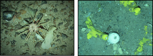
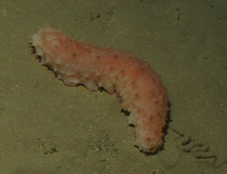
seabed, spotting sponges, redfish, sea cucumbers, sea stars, sea urchins and squat lobsters. This rocky material, deposited thousands of years ago by icebergs ploughing through the seabed, provides a complex habitat and attachment surface for a wide range of deep-sea creatures.

The 'A Team' in the camera operations centre.
15:00: Time for more coffee. We have around 30 minutes to travel between each camera transect, during which we refresh our caffeine levels whilst keeping on top of our data management. When we’ve completed our data entry, Dave the deck technician drops in to teach us some nautical knot-tying skills.

17:30: We change out of our protective gear and head up to the mess for a delicious curry. There are a few faces missing at the table… some newly arrived scientists are suffering a bout of sea sickness and are tentatively nibbling on crackers in their cabins. This debilitating condition is unfortunately all too common up here in the Atlantic due to the stormy November weather. Just another sacrifice in the name of science!

00:00: We made it! After 12 hours of toil we are delighted to find we’ve completed 11 transects (one more than the night shift!). Our colleagues arrive to relieve us, and we are free to enjoy twelve hours of unfettered freedom and sleep before we come back and do it all over again.

Surveying the depths of the Wyville-Thomson Ridge MPA which provides a complex, rocky-reef habitat for various species.
To find out more information about the Wyville-Thomson Ridge MPA, check out the JNCC Site Information Centre

For more updates from the team, make sure to follow @JNCC_UK on twitter and this blog by entering your email address on the right hand side of the screen.

Written by 
Tammy Noble-James.
Seabed images copyright JNCC/MSS.
Non-seabed images copyright Tammy Noble-James/JNCC.

Tuesday 31 October 2017

North East Faroe-Shetland Channel NCMPA: Blog #4

We’re halfway there…

Hello once more from the Scotia, where the first leg of our JNCC and Marine Scotland Science Marine Protected Area monitoring survey has drawn to a close. We have begun making our way from North-east Faroe Shetland Channel NCMPA to Lerwick, Shetland for a day in port to facilitate a staff change before we make for our second survey site (Wyville Thomson Ridge SCI), which is situated to the north-west of Scotland. 


We have collected a lot of very useful information about this site in what has been a great week and a half out here on the north-eastern edge of the UK’s waters.

We have collected data from four survey areas (Boxes A, B, C, and D). The black crosses in the image below show the 37 locations where we completed drop-frame camera stations in Boxes A, B and C. We also completed 15 camera chariot transects in these boxes and collected 8 seabed samples from Box D. 


Thanks to the persistent hard work of the crew and JNCC and Marine Scotland Science scientists aboard, and some good luck with weather, we have achieved our objectives and now have a comprehensive dataset describing the deep-sea sponges and other animals we have observed (some of which have been mentioned and shown in previous blogs), and the seabed habitats which support them. This dataset can now be used to help monitor change within this MPA into the future. 

We will continue to blog throughout the second leg of this survey, so please do stay tuned for new updates and images from the good people on the good ship Scotia!


To find out more information about North-East Faroe Shetland Channel, check out the JNCC Site Information Centre

For more updates from the team, make sure to follow @JNCC_UK on twitter and this blog by entering your email address on the right hand side of the screen.

Written by Joey O’Connor
Images copyright Joey O’Connor/JNCC.

Monday 30 October 2017

North East Faroe-Shetland Channel NCMPA: Blog #3

Sid the stonecrab left the house early today to get a head start on his early morning seabed scavenge. At these depths there is no natural light, the water is clear and nearly as cold as that at the poles. The seabed here is not barren, however... far from it. Sid passes through areas thick with a variety of deep sea sponges growing in fantastic forms and sizes as he forages. The area supports a variety of other animals too like cushion stars, brittle stars, pencil urchins, anemones, squat lobsters and fish like ling, torsk and deep sea red fish.


Suddenly, a brightness he has never seen before descends from above, stopping just metres away from him. The brightly lit metallic object pauses for only a moment before moving on, bobbing along its way in the deep. Little does Sid know that hundreds of meters above him, the Marine Research Vessel Scotia is carrying out an extensive survey of the sponge grounds that are his home. In a joint operation, JNCC and Marine Scotland Science (MSS) have been surveying the North-east Faroe-Shetland Channel Nature Conservation Marine Protected Area (NEF NCMPA) for the last week as part of the UK’s MPA monitoring. 


Now that the storm on the surface has abated, the sea is again calm enough to resume survey operations. The joint survey team have been collecting video and photographs of the seabed for the last 36 hours using a dropframe camera system. The sophisticated camera systems are repeatedly lowered off the back of the ‘Scotia’ into the deep in search of their quarry: the deep-sea sponges and their associated animals, including Sid (much to his surprise!). The intrepid crew, a mixture of professional seamen and scientists, will keep up this work twenty-four hours a day until they have collected enough footage to form a picture of this little-known area of seabed. This work will help to better understand and protect Sid’s home among the amazing deep-sea sponges of the Northern North Sea. 


To find out more information about North-East Faroe Shetland Channel, check out the JNCC Site Information Centre

For more updates from the team, make sure to follow @JNCC_UK on twitter and this blog by entering your email address on the right hand side of the screen.

Written by Henk van Rein
Seabed images copyright JNCC/MSS.
Non-seabed images copyright Henk van Rein/JNCC.

Thursday 26 October 2017

North East Faroe-Shetland Channel: Blog #2

We have been busy here at North-east Faroe Shetland Channel since the last blog post. We have all managed to get our sea legs now and have managed to complete all of the chariot video tows. This type of video tow is useful as the equipment can be towed much quicker and for longer than the drop frame camera system (more on that later), allowing us to view a much larger area of seabed. During these tows we have seen a large variety of deep-sea sponges and many different deep-sea fish.


To make the most of the time we have at sea, the team has been split into two, allowing sampling to happen 24 hours a day. Half the team works the “day” shift, midday to midnight, and the other half work “night” shifts midnight to midday. 

We have also been making headway with the grab sampling. This consists of sending the equivalent of a large spade down to the 500m depth and scooping up a small amount of the seabed which we then subsample to investigate sediment particle size. The remainder of the sample is sieved through two different sized sieves to see what marine life and seabed material we have picked up in this area. 


Listening to a variety of musical tunes, going through the decades from 70’s to 80’s, through the shifts has helped the work move along, with the addition of tasty meals and plenty of chocolate and biscuit snacks. We are now moving onto the drop-camera survey. This camera allows us to take high quality still images, which will later be used to identify the different animals seen in the chariot videos.

Sadly, Storm Brian managed to find us yesterday evening, raising the waves to stomach churning levels. Work was suspended as the winds picked up to levels which did not allow us to continue grabbing or video work. This gave the team plenty of time to make sure all the information we had collected was backed up to the various hard drives and computers. It also allowed some time for making sure all of the data is in the correct format, writing blog posts and fixing any computer glitches.

To find out more information about North-East Faroe Shetland Channel, check out the JNCC Site Information Centre

For more updates from the team, make sure to follow @JNCC_UK on twitter and this blog by entering your email address on the right hand side of the screen.

Written by Jessica Taylor

All Images Copyright JNCC. 

Monday 23 October 2017

North East Faroe-Shetland Channel NCMPA: Blog #1

Welcome to the 2017 monitoring survey by Marine Scotland and JNCC onboard RV Scotia to North-East Faroe-Shetland Channel Nature Conservation Marine Protected Area (NCMPA) (Figure 1) and Wyville Thompson Ridge Site of Community Interest (SCI).

Figure 1. North-East Faroe-Shetland Channel NCMPA sampling locations, shown as ‘Box A’ (red points), ‘Box B’ (blue points), ‘Box C’ (purple points) and ‘Box D’ (green points).

The survey is split in to two legs, ten days for the North-East Faroe-Shetland Channel NCMPA and a further ten days on location at Wyville Thompson Ridge SCI. Leaving Aberdeen at 5am on Friday 19th October meant that during the 36-hour transit we had time to prepare all of the equipment, familiarise ourselves with the data management processes and standard operating procedures, and get our body clocks into our various shift patterns allowing us work around the clock (Figure 2).

Figure 2. Familiarisation with (A) the equipment and (B) relevant processes and procedures.
We arrived at North-East Faroe-Shetland Channel NCMPA at midday on Saturday 21st October. The first shift lasted from midday until midnight using Hamon grabs to collect sediment samples from ~660m for particle size and infaunal analysis and working alongside colleagues from Marine Scotland Science who directed the chariot tow video equipment operations (Figure 3B). The video footage from the chariot tow showed coarse-gravelly sediment prevailing, a variety of sponges (potentially including massive, pedunculate, papillate, and flabellate sponges) and multiple sighting of chimera fish. With the first shift over, all chariot tows within ‘Box A’ were complete (Figure 3).

Figure 3. (A) Hamon grab being deployed and (B) Chariot tow set-up.
As the first night shift began the weather took a turn for the worst, with Storm Brian becoming ever closer. This meant that the nights sampling had to be postponed from midnight to 8am on the 22nd October. During this time, the JNCC night shift collated all the metadata from the previous shifts work, backed everything up on multiple hard drives, and ensured all positional information relating to the day’s sampling efforts were stored and correct.

Figure 4. (A) Hamon grab being deployed at night and (B) sea swell preventing further chariot tows and grabs today.
As the first night shift ended, the weather had calmed down considerably, enabling us to begin chariot tow work in ‘Box B’.

To find out more information about North-East Faroe Shetland Channel, check out the JNCC Site Information Centre

For more updates from the team, make sure to follow @JNCC_UK on twitter and this blog by entering your email address on the right hand side of the screen.

By Bekah Cioffi
All images property of Bekah Cioffi.


Monday 16 October 2017

North-East Faroe Shetland Channel NCMPA


North-East Faroe Shetland Channel Nature Conservation Marine Protected Area (NCMPA) is the other site JNCC and Marine Scotland Science are visiting on the upcoming survey.


Designated in 2014, North-East Faroe Shetland Channel is the largest NCMPA in UK waters, stretching from 330m to over 2,000m deep. The focus of this survey are the deep-sea sponges, known to thrive in the nutrient rich 400-600m waters.

Up to 50 different species of Deep-sea sponges live in this channel, providing shelter for a large range of small sea life and a perch for animals that filter food from passing currents.

Probes test temperature and how salty the water is (salinity) to allow the team to paint a better picture of where these deep-sea sponges live. Live video footage and images add to this picture allowing us to identify the sponges. 

The main aim of this survey is to complete Type One monitoring, this is where a robust dataset is collected which can be used to compare this environment now, to how it is in the future.

To find out more information about North-East Faroe Shetland Channel, check out the JNCC Site Information Centre

For more updates from the team, make sure to follow @JNCC_UK on twitter and this blog by entering your email address on the right hand side of the screen.


Wednesday 20 September 2017

New JNCC and Marine Scotland Science survey setting sail soon!


JNCC and Marine Scotland Science staff are setting sail for the north-eastern Scottish waters in the next scientific survey at the end of October.


The focus of this 20-day survey on MRV Scotia are the stony reefs of Wyville-Thomson Ridge cSAC/SCI (candidate Special Area of Conservation/Site of Community Importance) and the deep-sea sponges of North-east Faroe-Shetland Channel NCMPA (Nature Conservation Marine Protected Area) .


More information on North-east Faroe-Shetland Channel will follow in another blog post soon!


Wyville-Thomson Ridge has been a special area of conservation since November 2011. This plateau of rocky ground can be found in the Atlantic Ocean and divides the warmer water of the Rockall Trough from the cooler Faroe-Shetland Channel waters. This feature is unique to UK waters, allowing nutrients to mix and a large range of species to thrive.  

Another exciting feature of Wyville-Thomson Ridge is the large areas of stony reef, thought to have formed at the end of the last ice age by the movement of massive icebergs.


This stony reef allows a wide variety of marine life to live on the ridge. This marine life varies from deep-sea sponges, feather stars and coral that are anchored to the seabed, to the more mobile sea cucumbers, sea urchins and brittle stars.

Live video footage and images from a camera will allow the team to explore Wyville-Thomson Ridge and to inform how best to protect this unique area and the animals that live within it.  


To find out more information about Wyville-Thomson Ridge and the amazing animals that live there head to JNCC’s Site Information Centre and for more updates on how the team are preparing for survey make sure to follow the blog by giving your email on the panel on the right hand side of the screen. 


Monday 31 July 2017

Surveying Bassurelle Sandbank and Wight-Barfleur Reef cSACs/SCIs

Bassurelle Sandbank


Having arrived at Bassurelle Sandbank our scientists began work collecting grab samples to look at the creatures living within the sediment and using a towed camera sledge to record footage of what is living on the seabed.

Sea Potatoes on a 5mm sieving table. Image © JNCC/Cefas 2017.
Animals like sea potatoes (Echinocardium cordatum), a type of sea urchin, were collected in grab samples. Sea Potatoes use the spines which cover their bodies to burrow into the sand, where they feed on organic debris amongst the sediment.


Grab and camera sledge sampling stations at Bassurelle Sandbank (note that some grab stations were visited more than once).
In total at Bassurelle Sandbank, 140 grab samples were collected, along with 26 video transects. The information that these samples tell us about the communities of organisms that make this sandbank their home will help JNCC and Cefas to understand how to better protect this site and ensure its condition is maintained and improved.


Wight-Barfleur Reef


At Wight-Barfleur Reef the survey objective was to collect images of the rocky reefs that occur at the site, as well as the animals that inhabit them. As with Bassurelle Sandbank, this information will be used to monitor the condition of the site.


The first job was to collect acoustic data to enable our scientists to identify areas likely to have reef so that a camera could be lowered down to examine the habitat. As Wight-Barfleur Reef is so big, sampling took place within a few more manageable-sized boxes inside the site boundary.

Example map of one area of Wight-Barfleur Reef visited on this survey. This is to demonstrate how drop camera stations are planned by first collecting blocks of acoustic data.


The HD video and still images revealed a diverse community of sponges and bryozoans, as well as animals that use the reefs for shelter and as a feeding ground.

Images from Wight-Barfleur Reef: (a) Elephant hide sponge (Pachymatisma johnstonia) growing on a rocky ridge. (b) An edible crab (Cancer pagurus) shelters under a rock. (c) A bryozoan colony, known as a “Ross Coral” (Pentapora foliacea), forms in a cluster of rose petal-like sheets. (d) A brightly coloured male cuckoo wrasse (Labrus mixtus) swims amongst the cobbles. Images © JNCC/Cefas 2017.


In total 82 drop camera transects were completed and acoustic data was acquired from ~170.5 km2 of seabed.


Having attained all the samples needed, the survey came to an end. Work will now begin on analysing the samples that were collected, which will help us monitor the site over time. JNCC would like to thank all those involved who helped make this another successful JNCC/Cefas partnership survey.

Heading west towards the sunset and our final stop on this survey at Falmouth. Image © JNCC/Mike Nelson.


James Albrecht
JNCC Offshore Seabed Survey Ecologist

Friday 16 June 2017

Fauna from the canyons


 Over the last week we’ve been exploring the deeper areas of the Canyons from around 1000m to ~1700m. It’s been a really varied landscape from rippled sand with gravel patches and the odd boulder, to areas of bedrock and cliff-like overhangs. Each tow has been a big surprise, not knowing what fauna we might see, or if the geology will surprise us with a rocky landscape.

The most spectacular tows have been those comprising the Feature of Conservation Importance habitat Coral Gardens. These have shown us a variety of coral species from bamboo corals Isididae, antipatharians (black corals) to scleractinians (hard corals). The scleractinians have mainly been Madrepora oculata, with some Lophelia pertusa. Bamboo corals are named for their stems which have a ‘joint-like’ appearance similar to bamboo. We’ve seen the bamboo coral Lepidisis sp., amongst others, and the antipatharian Stichopathes sp., an orange coral with a spring-like coil morphology. We’ve also seen beautiful fan-shaped gorgonian corals and the aptly-named bubblegum coral Paragorgia sp.. Although much rarer, there have been a few sponges, mainly encrusting on rocks and boulders, but also what we think may be Phakellia sp., and a Hexactinellid glass sponge. 
Glass sponge and gorgonians
Phakellia sp and Paragorgia sp
Madrepora oculata and Lepidisis sp
Some sandy areas have shown us small clumps of the bamboo coral Acanella sp. and the occasional cup coral, Caryphyllia sp. We also saw a beautiful ‘forest’ of stalked crinoids. Although they look like plants (known as ‘sea lilies’), crinoids are actually animals, and are attached to the seabed via their stalk, with a mouth on the top surface that is surrounded by feeding arms. Stalked crinoids were the trigger for deep-sea exploration back in the 19th Century – see this blog from the Australian Natural Environment Science Programme - https://www.nespmarine.edu.au/crinoids-were-trigger-deep-sea-exploration

Acanella sp

Stalked crinoids

Stichopathes sp

Tuesday 13 June 2017

North West of Jones Bank and the Canyons Survey Update


On the 22nd of May 2017 a partnership JNCC and Cefas monitoring survey to North-West of Jones Bank (NWJB) MCZ and The Canyons MCZ departed from Lowestoft. Just under 48 hrs later RV Cefas Endeavour arrived on site at NWJB MCZ having replaced a Waverider buoy south-west of the Isles of Scilly. The buoy is now running, with the data viewable.

The target monitoring features at NWJB MCZ are subtidal mud (
http://jncc.defra.gov.uk/page-5802) and seapens and burrowing megafaunal communities (http://jncc.defra.gov.uk/page-6028). These mud habitats tend to form in low energy environments where sediments can settle out and become fairly compacted.

At NWJB MCZ two day grabs and a 200m video sledge transect were collected at 71 stations. The day grabs at NWJB have been sampled for macrofauna, particle size analysis (PSA, aka sediment size) and organic, carbons and nitrogen. When sieving out the mud, the fauna has been mainly polychaetes (aka worms) of all shapes and sizes, which we need to pluck out of the sieve to make sure we don’t miss any of the important diversity in the final analysis. We have also found the occasional Nephrops, a small crustacean you may know as scampi. These bury in muddy sediments, forming semi-permanent burrows that create part of the Feature of Conservation Importance ‘Sea-pens and burrowing megafauna’. We’ve also found a few amphipods, crabs and sea-pens in the grabs.


In addition to the grab and video data, 14 NIOZ cores and 4 day grabs were acquired to support wider work on shelf biogeochemistry being carried out by Cefas.


After a 10 hours transit to the south-west the RV Cefas Endeavour arrived at The Canyons MCZ. Work has been completed on interfluves, the shallower area (200-500m) between the canyons themselves which reach down to ~2200m. The canyons themselves are named Explorer and Dangeard, with Explorer being the northern one of the two. The habitat on the interfluves is mainly muds with a veneer of sand, but the site is also comprised of ‘mini mound’ features, where coral may have been present in the past.


Drop camera transects and NIOZ cores are being carried out on the interfluves. In total 113 stations have been sampled across the two interfluves. Some interesting species have been seen at the interfluves. This included a large number of the anemone Actinauge richardi. This anemone doesn’t usually live attached to a hard surface or burrow into soft sediments like other anemones. Instead its base forms an almost enclosed cup which encloses mud and sand acting as an anchor onto the soft sediments. 


Different species of sea-pen have also been seen, including the tall sea-pen Funiculina quadrangularis, the phosphorescent sea-pen Pennatula phosphorea and what we think may be the deep-sea species Kophobelemnon sp., though this is not a confirmed identification. 


Numerous sea cucumbers have been dotted around, mainly the species Parastichopus tremulus, and a few pencil urchins Cidaris cidaris


Some examples of a soft coral, which we struggled to identify, were found in the early hours of Sunday morning (4th June), with its polyps retracted. Luckily later in the day we captured a lovely example of it with its polyps out (and a sneaky squat lobster hanging out). On discussion with some of our deep-sea colleagues, we think it is a soft coral of the Alcyoniidae family, likely to be a Drifa species. These can be identified fairly well by their shape as they look rather like cauliflower.


During our drop-camera transects on the interfluves, we have identified five species of Elasmobranchs, including some deep-water species. One of these species is the velvet belly lanternshark (Etmopterus spinax), which is one of the smaller shark species with a maximum total length of 60cm. The individuals we have seen have been ~30cm in length. This species occurs in depths between 200-500m and uses hormones to control small pigment-lined structures called photophores (seen as dark blotches on the belly) to emit light for camouflage (to predators below), and possibly to communicate with other lanternsharks.